Overview

Warmer, more humid weather affects the snow used to build igloos, which serve as shelters during winter hunts. Photo © Bryan and Cherry Alexander Photography

Inuit whale hunters paddle an umiak made from wood and seal skins. Photo © Bryan and Cherry Alexander Photography

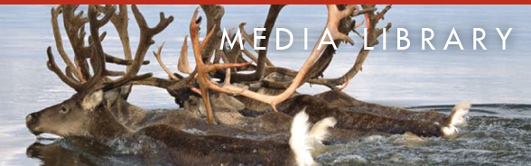
Rangifer tarandusare known as caribou in North America and reindeer in Eurasia. Photo © Kaisten Heuer

The light color of snow and ice reflects most of the Sun’s energy back into space—one reason the Arctic is so cold. Illustration The M Factory © Smithsonian Institution

Polar bears (Ursus maritimus) rely on sea ice as a platform to catch seals and to travel. Photo © Chris Linder Photography
What is the Arctic?

The Arctic can be defined by the Arctic Circle, an imaginary line at 66°33’ North Latitude. Map The M Factory © Smithsonian Institution

The Arctic can be defined by the polar treeline, the northernmost limit of tree growth. Map The M Factory © Smithsonian Institution

The Arctic can be defined by high latitude areas where the average summer temperature does not exceed 10°C (50°F). Map The M Factory © Smithsonian Institution

The Arctic can be defined by the political boundaries set by the eight nations with territory in the region.
Map The M Factory © Smithsonian Institution

On average, Arctic air temperatures—like those globally—have warmed since 1900. Graph The M Factory © Smithsonian Institution

This image shows the decrease in the seasonal melt zone of the Greenland Ice Sheet from 1992 (left) to 2002 (right). Graphic © Konrad Steffen and Russell Huff, University of Colorado, CIRES
Arctic Meltdown

Per decade, since 1979, the loss in the extent of Arctic summer sea ice has equaled an area the size of Arizona. Graph The M Factory © Smithsonian Institution.

This ceremonial mask represents a seal blowing air bubbles as it comes to the surface — the sound hunters listen for. Photo Chip Clark © Smithsonian Institution

In recent years, some hunters find it too dangerous to step onto the sea ice, as it shifts around more now. Photo © Bryan and Cherry Alexander Photography

Cold, dense water in the Arctic merges with salty water from the Gulf Stream, which helps drive global ocean circulation. Illustration The M Factory © Smithsonian Institution

Most climate models project continued sea ice losses that could range from a 10% to 100%. Arctic Climate Impact Assessment © Clifford Grabhorn/Grabhorn Studio

Walrus (Odobenus rosmarus) dive from sea ice to the sea bottom to feed on clams and other invertebrates. Photo © Chris Linder Photography
Slip Sliding Away

A stormy sea lashes the village of Shismaref, Alaska, where the coastline has eroded 30–90 m (100–300 ft) in the past 30 years. Photo © The Nome Nugget

Shishmaref, Alaska: coastal erosion is forcing the village to relocate to Tin Creek on the mainland. Map The M Factory © Smithsonian Institution

Barrow, Alaska: a coastal community where decreased sea ice has increased the affect of some coastal storms. Map The M Factory © Smithsonian Institution

Some of the greatest decreases in sea ice have occurred in the Beaufort and Chukchi Seas, increasing the impact of coastal storms.Graphic © National Snow and Ice Data Center, F. Fetterer and K. Knowles
Caribou: Arctic Lifeline

Sámi settlements: The Sámi and their ancestors have lived in the Arctic and herded reindeer for thousands of years. Map The M Factory © Smithsonian Institution

Sámi herders use snowmobiles to round up their reindeer. Travel is often difficult if the snow cover is thin. Photo © Bryan and Cherry Alexander Photography

The Sámi wear boots with a turned up toe that hooks under the leather strap on a ski. Photo Donald Hurlbert © Smithsonian Institution

When it is cold, Sámi herders carry a sewing kit so they can make repairs to torn clothing on the spot. Photo Donald Hurlbert © Smithsonian Institution

Sámi herders wear a reindeer-hide jacket called a “kolt.” Decorative patterns vary from village to village. Photo Donald Hurlbert © Smithsonian Institution

Innu settlements: Approximately 16,000 Innu live in nine Quebec and two Labrador communities in Arctic Canada. Map The M Factory © Smithsonian Institution

Innu hunters use to wear caribou skin coats decorated with motifs that represented a symbolic map of the spirit world. Photo Donald Hurlbert © Smithsonian Institution

The Innu used fork-like sticks to paint complicated patterns on their clothing. Photo Donald Hurlbert © Smithsonian Institution

Peary caribou (Rangifier tarandus) is a sub-species of caribou now at risk of extinction. Photo © David L. Mech
Eyewitnesses to Change

This ringed seal pup is seriously underweight because its snow den melted before it was old enough to be weaned. Photo © Brendan P. Ford

Vadin Yenan (right) consults with community elder Chester Noongwook (left) while illustrating Yupik sea ice terms. Photo Igor Krupnik © Smithsonian Institution

Yupik-speaking Eskimos on St. Lawrence Island, Alaska, have some 100 terms for sea ice and ice formations. Map The M Factory © Smithsonian Institution

Illustration for “siku:” the primary Yupik term for ice, as well as for the ice-covered Bering Sea. Illustration by Vadin Yenan

Illustration for “analghu:” Yupik term for floating pressure ice ridges. Ice piled higher than neighboring ones. Illustration by Vadin Yenan

Illustration for “siinguraq:” Yupik term for stream of dense ice carried by a north or south current or low tides. Illustration by Vadin Yenan

Illustration for “Sigiin:” New ice formed within cracks in an ice flow. Good to walk on. Illustration by Vadin Yenan

Driftwood among the remains of an 8,000-year old house on this Siberian island tells of the Arctic’s warmer past. Photo William Fitzhugh © Smithsonian Institution
Exhibit Interactives

Climate Rollercoaster: The Arctic’s climate has changed many times during the past 20,000 years. Illustration The M Factory © Smithsonian Institution

Predicting Change: Caribou Interactive
For thousands of years, the Gwich’in people of Arctic Canada have observed and hunted the Porcupine Caribou Herd.